GSC Open File D3772
Reanalysis of Stream Sediments from the Little Nahanni River Map Sheet (105I), Yukon and Northwest Territories
P.W.B. Friske, M.W. McCurdy, S.J.A. Day, C.C. Durham
Introduction
A reconnaissance geochemical survey of stream sediments and waters in the Little Nahanni River (NTS 105I) map area was carried out in 1981 as part of the Nahanni Integrated Multidisciplinary Pilot Project (NIMPP). The NIMPP was established by the Geological Survey of Canada to focus the efforts of personnel from different geological disciplines (Goodfellow, 1982). In addition to reconnaissance coverage of stream sediment and water geochemistry and bedrock and surficial geology, mineral deposit studies and detailed studies of plutonic rocks were carried out (Gordey & Andersen, 1993). Information derived from these studies was used primarily to determine areas of high potential for Pb, Zn, Ba and W.
Granitoid plutons and their extensive hornfels zones have recently become the focus of gold exploration as a result of two recent exploration successes, Fort Knox in Alaska and Brewery Creek in Yukon (Hart, 1999). Mid-Cretaceous granitoid intrusions, generally referred to as the Tombstone Plutonic Suite (TPS) (Poulsen et al., 1997), form a narrow belt of lithologically diverse plutons extending from Alaska eastwards across Yukon to the Northwest Territories (Lang et al., 1997). Mid-Cretaceous granite and granodioritic intrusions of the Selwyn Plutonic Suite (Gordey & Anderson, 1993) within the map area and in adjacent regions are now included with the TPS, based on location, age and similarities in metallogeny (Duncan et al., 1998). Gordey & Andersen (1993) estimate that 7% of the map area (105I) is underlain by granitoid plutons. Nearly all TPS intrusions contain Au-mineralization (Baker et al., 1999). Mineralization is widely developed in the TPS, with a defining metal assemblage of Au-W-Bi, variable Sn-As-Sb-Mo and minor Pb-Zn-Ag (Lang et al., 1997).
Under the terms of the Canada/Yukon Geoscience Program, the Government of Yukon, the Department of Indian and Northern Affairs and the Geological Survey of Canada agreed to conduct a joint research project consisting of reanalysis of previously collected stream sediments for gold and 25 other elements. The addition of gold and many of the lithophile elements associated with felsic plutons in continental arc environments (Lang et al., 1997) to the existing suite of elements may help identify potential areas of large tonnage-low grade gold mineralization within the Little Nahanni River map area. Data files in this open file include original field and analytical data for stream sediments and waters and new data for stream sediments.
Physiography
The Little Nahanni River (National Topographic System (NTS) 105I) map area (Fig. 1, Fig. 2) covers 11,489 km2 (Sebert & Munro, 1972) between latitude 62ºN and 63ºN and longitude 128ºW and 130ºW. The border between Yukon Territory and Northwest Territories (District of Mackenzie) divides the map sheet roughly diagonally from northwest to southeast.
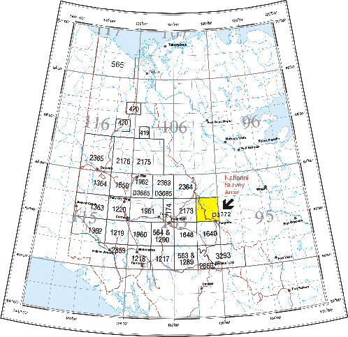
Fig. 1. Map of Yukon Territory showing survey area (in yellow) and current GSC open file numbers for geochemical data releases. Coverage consists of stream sediment and water surveys except for GSC Open File 2860 (NTS 105A, Watson Lake) which is a lake sediment and water survey.
The valley of the South Nahanni River separates the Mackenzie Mountains in the northeast from the Selwyn Mountains (and Logan Mountains within the Selwyn Mountains) and Yukon Plateau in the southwest half of the survey area (Fig. 2).
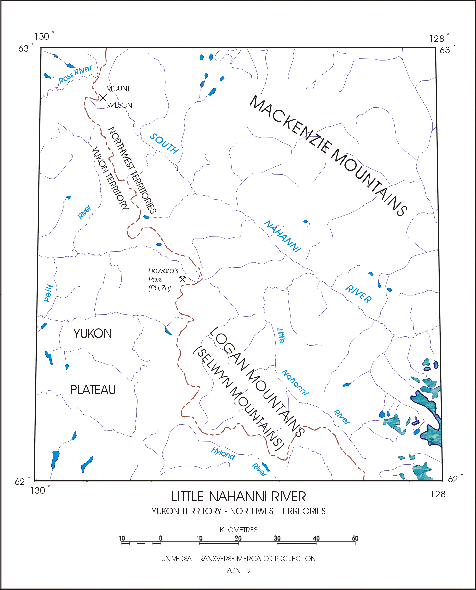
Fig. 2. Map of survey area (NTS 105I) showing major rivers and geographic features. Areas of textured blue in the southeast indicate glacier cover.
The land surface is rugged and consists mainly of slope, summit and plateau (Jackson, 1987). Elevations range from 762 m to 2590 m (Gordey & Anderson, 1993), and more than 75% of the survey area lies between elevations of 1220 and 1820 m (Jackson, 1987). Glaciers are found at higher elevations of the Ragged Range, in the southeast corner of the map sheet. The timberline is located between elevations 1375 m to 1525 m, below which bedrock exposure is rare (Gordey & Anderson, 1993).
A major drainage divide between the Little Nahanni River and the Pelly, Ross and Hyland Rivers is delineated by the Yukon-Northwest Territories border. Streams in Yukon drain west to southwest and in the Northwest Territories flow southeast towards the Mackenzie River. Thousands of small streams flow from higher elevations, forming dendritic drainage patterns.
Geology (from Gordey & Anderson, 1993)
The survey area falls within two major depositional environments, the Mackenzie Platform and the Selwyn Basin (Gordey & Anderson, 1993), a late Precambrian to Middle Devonian platform-basin assemblage (Fig. 3). To the southwest, turbiditic sandstone, shale, deep-water limestone and chert of the Selwyn Basin are gradually interstratified moving to the northeast with shallow-water sandstone, dolostone and limestone of the Mackenzie Platform. Euxenic black shale of Early Silurian age is host to important stratiform Pb-Zn deposits.
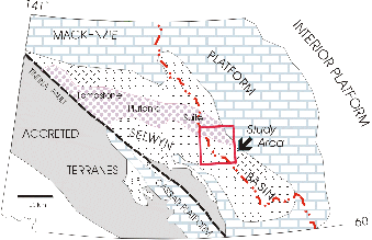
Fig. 3. Major tectonic and depositional areas in the area of the survey (modified from Duncan et al., 1998).
Late Devonian shale overlies Mackenzie Platform to the northeast. To the southwest, coarse clastics in a number of submarine fan complexes deposited turbiditic quartz-chert sandstone and chert pebble conglomerate derived from elevated fault blocks of older Selwyn Basin strata. Stratiform barite and Ba-Pb-Zn deposits associated with local faulting form important deposits within black siliceous shale of Middle to Late Devonian age.
Devonian-Mississippian turbiditic clastics are succeeded by mid-Mississippian quartz sandstone and shale and shale, chert, minor sandstone and siltstone of Early Permian and Triassic age.
Granite and granodiorite intrusions of mid-Cretaceous age underlie about 7% of the survey area. Circular in plan, plutons vary between one and 20 km in diameter and intrude and hornfels strata as young as Triassic. Plutons range in age from 88 to 114 Ma. Plutons can be classified into two groups depending on whether or not hornblende is present, or alternatively, whether or not two micas (muscovite and biotite) are present. Tungsten in skarns is associated with two-mica plutons intruding argillaceous limestone.
Metamorphic grade is equivalent to subgreenschist facies.
Surficial Geology (from Jackson, 1987)
The survey area was intensely glaciated during the Wisconsinan-age McConnell advance. At climax, one or more ice centres existed over the area. Ice flow was directed by the underlying topography.
As noted earlier, little bedrock is exposed below approximately 1500 m. The most common glacial deposits are tills deposited as blankets or veneers over bedrock. Glaciofluvial deposits consisting primarily of gravel form kames, eskers and planar deposits in most valleys. Glaciolacustrine silts and clays are found where glacial ice impeded drainage during glaciation and occur extensively in the South Nahanni River valley, especially near Mt. Wilson. Bogs have formed in areas of poor drainage.
Mineral Deposits
Until recently, mineral exploration was directed towards four types of mineralisation recognized within the survey area:
Early Silurian or Devonian shale or chert hosted stratiform Pb-Zn;
replacement Zn-Pb deposits in platform carbonates of the Mackenzie Platform;
Zn-Pb veins peripheral or within mid-Cretaceous granitic plutons (Bonham-Carter & Goodfellow, 1986);
4. W skarn deposits developed within limestone host rocks adjacent to mid-Cretaceous granitic plutons (Gordey & Anderson, 1993).
The Canada Tungsten mine, located immediately south of the southeast corner of the survey area, was once the world’s largest producer of scheelite concentrate (Dick & Hodgson, 1982).
Plutons and surrounding host rocks of the Tombstone Plutonic Suite that were originally the target of tungsten exploration are now the focus of exploration for gold. The development of effective heap leach mining methods in cold terrains and exploration successes at Fort Knox (Alaska) and Brewery Creek (Yukon) have focused recent exploration in Yukon in areas magmatic rocks of the TPS occur (Hart, 1999).
Mineralization is varied and appears to be controlled by the location relative to the intrusion and the nature of the host rock. Within intrusions, sheeted Au quartz vein mineralization occurs, characterized by metal assemblages of Au-Bi-W-As-Te (Mo-Sb) (e.g. Fort Knox, Dublin Gulch) (Baker et al., 1999). Mineralization in hornfels zones includes W skarns and Sn and Au-bearing breccias (e.g. Ray Gulch, MacTung) (Lang et al., 1997). Outside of contact zones Pb-Zn-Ag-Au veins are found (e.g. Keno Hill) as well as Au-bearing disseminated to replacement deposits (e.g. Brewery Creek) (Baker et al., 1999; Lang et al., 1997).
Collection Procedures and Sample Management (Original Surveys)
Stream sediment and water samples at 984 sites were collected at an average density of one sample per 12 km2 throughout the 11489 km2 comprising the Nahanni mapsheet (NTS 105I). For the purposes of sampling, preparation and analytical control, sample numbers were divided into blocks of 20, each block consisting of 17 routine samples, one field duplicate, one blind duplicate and one control reference standard. Further details can be obtained from Garrett (1974).
At GSC laboratories in Ottawa, field-dried stream sediment samples were air-dried, sieved to minus-80 mesh (177 µm) and ball-milled to minus-150 mesh. Control reference and blind duplicate sample positions were filled during sample preparation. In the case of stream waters, the control reference positions were filled in the field with one of three control standards collected near base camp. The blind duplicates for stream waters were left blank.
All stream waters were filtered through 0.45 µm filter paper before analysis.
Original Analytical Procedures (from Goodfellow, 1982)
Stream Waters
Uranium was determined by laser-induced fluorescence using a Scintrex UA-3. A 5 ml sample was pipetted into a quartz cell and a metaphosphate-phosphate solution (500 µl) added. The fluorescence of the uranyl phosphate formed and excited by the laser was measured. The method of standard additions was used.
Fluoride was measured using a specific ion electrode and an orion meter. A 5 ml sample of water and a 5 ml aliquot of buffer (TISAB) were measured using UV readings. Alkalinity and pH were determined simultaneously using a Radiometer TTT 81 digital titrator and pH meter respectively.
Anions Cl, NO3, PO4, SO4 were measured using ion chromatography. A 100 µl sample was separated on an exchange resin and the resulting solution passed through a high-capacity cation exchange resin to a conductivity cell. The eluent used was 0.003 M Na2CO3/0.0024 M NaHCO3. A Dionex System 12 was used.
Major cations Na, K, Ca, Mg, Mn, Fe, and Zn were determined by direct aspiration using a Perkin-Elmer 5000 atomic absorption spectrophotometer. An air-acetylene flame was used in all cases. A 2000 ppm potassium solution was used as an ionization buffer for Na analyses; 2000 ppm sodium for K analyses, and 2000 ppm lanthanum was used as a releasing agent for Ca analyses.
Table 1. Summary of Analytical Data and Methods for Waters
ELEMENT |
DETECTION LEVEL |
METHOD |
WATERS: T-Alk Alkalinity Ca Calcium Cl- Chloride F Fluoride Fe Iron K Potassium Mg Magnesium Mn Manganese Na Sodium NO3- Nitrate pH Hydrogen ion activity PO4- Phosphate SO4- Sulphate U Uranium Zn Zinc |
2.0 ppm 0.5 ppm 0.1 ppm 25 ppb 40 ppb 0.2 ppm 0.2 ppm 10 ppb 0.2 ppm 0.2 ppm - - 0.15 ppm 0.5 ppm 0.10 ppb 5 ppb |
|
AAS - atomic absorption spectrometry
GCM - glass Calomel electrode and pH meter
IC - ion chromatography
ISE - ion selective electrode
LIF - laser-induced fluorescence
TIT - titration
Stream Sediments
Zn, Cu, Pb, Ni, Co, Ag, Cd, Mn, Fe, Mo and V were determined by atomic absorption spectrophotometry after decomposition with a multi-acid total digestion. A 500 mg sample was leached over a period of four hours using a 5-ml aliquot of HF-HCl-HNO3-HClO4 (ratio 1:1:1:1). A final solution of 5% HCl was made up to a volume of 20 ml. All elements, with the exception of Mo, were atomized using an air-acetylene flame: a nitrous oxide-acetylene flame and a 1000 ppm Al solution as ionization buffer were used for Mo analyses. Background corrections were made on Ni, Cd, Ag, Pb and Mo analyses.
F was determined using an ion selective electrode and total ionic strength adjustment buffer (TISAB). A 500 mg sample was fused with Na2O3-KNO3 (9:1) at 800º C for 10 minutes.
Ba was analysed by x-ray fluorescence using pressed powder disks.
Colorimetric methods employing the standard dithiol method were used to measure W. The sample was fused at 800º C in nickel crucibles along with a mixture of Na2CO3, NaCl and KN03 (5:4:1).
P2O5 was determined colorimetrically using the H2SO4 and ammonium molybdate method after sample decomposition using HNO3-HCl-HClO4.
Loss-on-ignition (LOI) was recorded as a measure of the weight percent loss of volatiles after igniting a known weight at 450º C for four hours.
U was determined by neutron activation analysis using delayed neutron counting on a 3 g sample. The flux density used was 2 x 10¹¹ neutrons/cm2/s to 1 x 10¹² neutrons/cm2/s.
For the determination of As, Sb and Hg, a 750 ml sample was digested overnight in aqua regia (3 HCl:1 HNO3). It was then treated in a water bath for approximately four hours during which time the temperature was raised to 90º C. The final volume was 15 ml. Subsequently, As and Sb were measured by atomic absorption spectrophotometry using a silica tube heated to 900º C. The hydride of the element was formed with a sodium borohydride reducing agent. Mercury was determined similarly by measuring Hg vapour atomized in a silica tube heated to 100º C.
Instrumental Neutron Activation Analysis (INAA)
Weighed and encapsulated samples are packaged for irradiation along with internal standards and international reference materials. Samples and standards are irradiated together with neutron flux monitors in a two-megawatt pool-type reactor. After a seven-day decay period, samples are measured on a high-resolution germanium detector. Computer control is achieved with a Microvax II computer. Typical counting times are 500 seconds. Elements determined by INAA include: Ag, As, Au, Ba, Br, Cd, Ce, Co, Cr, Cs, Eu, Fe, Hf, Ir, La, Lu, Mo, Na, Ni, Rb, Sb, Sc, Se, Sm, Sn, Ta, Tb, Te, Th, U, W, Yb, Zn, and Zr. The sample weights are also reported. Data for Ag, Cd, Ir, Mo, Ni, Se, Sn, Te, Zn, and Zr are not published because of inadequate detection limits and/or precision.
Table 2. Summary of Analytical Data and Methods for Sediments
ELEMENT |
DETECTION LEVEL |
METHOD |
SEDIMENTS: Ag Silver As Arsenic As Arsenic Au Gold Ba Barium Ba Barium Br Bromine Cd Cadmium Ce Cerium Co Cobalt Co Cobalt Cr Chromium Cs Caesium Cu Copper Eu Europium F Fluorine Fe Iron Fe Iron Hf Hafnium Hg Mercury La Lanthanum LOI Loss-on-ignition Lu Lutetium Mn Manganese Mo Molybdenum Na Sodium Ni Nickel P2O5 Phosphoric anydride Pb Lead Rb Rubidium Sb Antimony Sb Antimony Sc Scandium Sm Samarium Ta Tantalum Tb Terbium Th Thorium U Uranium U Uranium V Vanadium W Tungsten W Tungsten Yb Ytterbium Zn Zinc AuWt Sample Weight |
|
AAS HY-AAS INAA INAA XRF INAA INAA AAS INAA AAS INAA INAA INAA AAS INAA ISE AAS INAA INAA CV-AAS INAA GRAV INAA AAS AAS INAA AAS COL AAS INAA HY-AAS INAA INAA INAA INAA INAA INAA NADNC INAA AAS COL INAA INAA AAS - |
AAS - atomic absorption spectrometry
COL - colorimetric methods
CV-AAS - cold vapour / atomic absorption spectrometry
FUS - fusion
GRAV - gravimetry
HY-AAS - hydride evolution followed by atomic absorption spectrometry
INAA - Instrumental Neutron Activation Analysis
ISE - ion selective electrode
NADNC - neutron activation followed by delayed neutron counting
XRF - x-ray fluorescence
Acknowledgments
W.D. Goodfellow, GSC, directed a regional stream sediment and water survey carried out in 1981 by Marshall, Macklin and Monaghan Ltd. Sediment samples were prepared for analysis by staff at the Geological Survey of Canada. Bondar-Clegg and Company, Ottawa, determined the following elements in stream sediments: Zn, Cu, Pb, Ni, Co, Ag, Mn, Fe, Mo, V, W, F, and Ba. Loss-on-ignition (LOI) and P2O5 were also determined. Nova Track Ltd., Vancouver, measured U in stream sediments using a delayed neutron activation method. A. I. MacLaurin, G. Gauthier and W. M. Alexander carried out the rest of the analytical work under the supervision of G. E. M. Hall. J.J. Lynch monitored analytical results.
Stream sediment samples were reanalysed by Becquerel Labs, Mississauga, Ontario, under the direction of P.W. Friske. The authors would like to thank W. Spirito for critically reviewing the open file and offering many helpful suggestions.
References
Baker, T., Lange, J., Mortensen, J.
1999: Regional metallogeny of the Tombstone Intrusive Suite, Yukon in Sixteenth Annual Cordilleran Exploration Roundup Abstract Book (Tintina Gold Belt Technical Session); British Columbia and Yukon Chambers of Mines, p. 14.
Bonham-Carter, G.F. and Goodfellow, W.D.
1986: Background corrections to stream geochemical data using digitized drainage and geological maps: applications to Selwyn Basin, Yukon and Northwest Territories; Journal of Geochemical Exploration, v. 25, p. 139-155.
Dick, L.A. and Hodgson, C.J.
1982: The MacTung W-Cu(Zn) contact metasomatic and related deposits of the northeastern Canadian Cordillera; Economic Geology, v.77, no. 4, p. 845-867.
Duncan, R.A., Russell, J.K., Hastings, N.L., Andersen, R.G.
1998: Relationships between chemical composition, physical properties, and geology of the mineralized Emerald Lake Pluton, Yukon Territory; in Current Research 1998-A; Geological Survey of Canada, p. 1-11.
Garrett, R.G.
1974: Field data acquisition methods for applied geochemical surveys at the Geological Survey of Canada; Geological Survey of Canada Paper 74-52, 36 p.
Goodfellow, W.D.
1982: Regional stream sediment and water geochemistry of the Nahanni map area (NTS 105I), Yukon and N.W.T.; Geological Survey of Canada Open File 868, 157 p.
Gordey, S.P. and Andersen, R.G.
1993: Evolution of the northern Cordilleran miogeocline, Nahanni map area (105I), Yukon and Northwest Territories; Geological Survey of Canada Memoir 428, 214 p.
Hart, Craig
1999: Variations in styles of gold mineralization associated with the Tombstone Plutonic Suite, Yukon in Sixteenth Annual Cordilleran Exploration Roundup Abstract Book (Tintina Gold Belt Technical Session); British Columbia and Yukon Chambers of Mines, p. 13.
Jackson, L.E.
1987: Terrain inventory and quaternary history of Nahanni map area, Yukon Territory and Northwest Territories; Geological Survey of Canada Paper 86-18, 23 p.
Lang, J.R., Thompson, J.F.H., Mortensen, J.K., Baker, T., Sillitoe, R.H.
1997: Intrusion-related Au mineralization associated with lithophile elements; an under-recognized metallogenic association in Geological Society of America (GSA) 1997 annual meeting (Abstracts with Programs), GSA 29; 6, p. 358.
Poulsen, K.H., Mortensen, J.K., Murphy, D.C.
1997: Styles of intrusion-related gold mineralization in the Dawson-Mayo area, Yukon Territory; in Current Research 1997-A; Geological Survey of Canada, p. 1-10.
Sebert, L.M. and Munro, M.R.
1972: Dimensions and areas of maps of the National Topographic System of Canada; Department of Energy, Mines and Resources (Surveys and Mapping Branch) Technical Report No. 72-1 (unpublished manuscript), 26 p.